Table of Contents
The Geography of the Silk Road: How Terrain Shaped History’s Greatest Trade Network
The Silk Road was far more than a trade route—it was a vast, intricate network of paths linking East and West, weaving together the landscapes, peoples, and cultures of three continents across thousands of miles and over a millennium. Stretching across some of Earth’s most formidable terrain—towering mountain ranges, merciless deserts, windswept steppes, and treacherous seas—the geography of the Silk Road shaped every aspect of its history: which goods could travel and survive the journey, which cities prospered and which languished, how cultures encountered and influenced each other, and ultimately which civilizations rose to dominance.
Understanding the geography of the Silk Road reveals how physical terrain and environment defined one of the most important trading systems in human history. The routes traders followed weren’t arbitrary choices—they represented humanity’s careful negotiation with geography, finding paths of least resistance through landscapes that often seemed designed to prevent passage. Mountains dictated where caravans could cross, deserts determined which oases became wealthy trading centers, rivers provided life-giving corridors, and winds governed maritime voyages.
This comprehensive exploration examines the Silk Road’s geography: what this legendary network was, which diverse terrains it traversed, how physical geography shaped trade patterns and cultural exchange, why certain cities became crucial nodes, what immense challenges geography imposed on travelers, and how this ancient network’s geographic logic continues influencing modern infrastructure.
What Was the Silk Road? Defining History’s Most Famous Trade Network
The Silk Road was a network of interconnected trade routes that connected China, Central Asia, the Middle East, and Europe from roughly 130 BCE to the 1400s CE. Despite its name (coined by German geographer Ferdinand von Richthofen in 1877), it wasn’t a single road, and silk—though important—was only one of countless goods that traveled its length.
Beyond Silk: What the Routes Carried
Goods Traveling West from China:
- Silk: The namesake commodity, prized in Rome and Persia for its quality and exotic origins
- Porcelain: Chinese ceramics admired for craftsmanship
- Paper: Revolutionary technology eventually transforming literacy globally
- Gunpowder: Initially for fireworks, later changing warfare
- Tea: Becoming beverage staple across Asia and eventually Europe
- Spices: Cinnamon, ginger, and other aromatics
- Lacquerware: Distinctive Chinese decorative items
Goods Traveling East to China:
- Horses: Central Asian breeds prized by Chinese military (particularly from Ferghana Valley, “heavenly horses”)
- Glassware: Roman and Persian glass unknown in early China
- Precious metals: Gold, silver from Mediterranean and Persian sources
- Gemstones: Lapis lazuli from Afghanistan, jade from Central Asia
- Wool and textiles: From Mediterranean and Persian looms
- Spices: From South and Southeast Asia via Indian Ocean connections
Ideas and Technologies (perhaps the most transformative cargo):
- Buddhism: Traveled from India through Central Asia to China, fundamentally transforming East Asian spirituality and culture
- Islam: Spread along trade routes from Arabia across Central Asia to China
- Christianity: Nestorian Christianity reached China via Silk Road
- Zoroastrianism: Persian religion influencing Central Asian thought
- Mathematical concepts: Indian numerals and zero concept traveling westward
- Astronomical knowledge: Exchange of celestial observations and calendar systems
- Agricultural techniques: Crops and cultivation methods spreading (grapes, alfalfa, pomegranates)
- Artistic styles: Greco-Buddhist art, Persian miniatures, Chinese motifs blending
Not a Single Road: A Network of Routes
The “Silk Road” was actually multiple routes that shifted over time based on:
- Political stability: Wars, empire collapses forcing route changes
- Climate variations: Droughts, floods altering viable paths
- Economic opportunities: New markets drawing merchants to different routes
- Technological developments: Better ships, camels, or navigation enabling new paths
- Taxation and tolls: Merchants avoiding excessive fees by finding alternatives
Main Branches:
- Northern Route: Through Mongolia and Kazakhstan steppes
- Central Route: Through Tianshan Mountains and Tarim Basin
- Southern Route: Skirting Taklamakan Desert’s southern edge through the Kunlun Mountains
- Maritime Routes: Sea paths connecting East Asia to South Asia, Middle East, and East Africa
This network structure meant that no single power could control all trade, creating competitive dynamics that both facilitated commerce and generated conflicts.
Time Span and Evolution
Han Dynasty Origins (130 BCE onwards): Chinese Emperor Wu sent Zhang Qian westward seeking allies against Xiongnu nomads. Though diplomatically unsuccessful, his expeditions opened Chinese awareness of western regions and markets, initiating sustained east-west trade.
Tang Dynasty Golden Age (618-907 CE): Chinese power extending westward, creating unprecedented security and prosperity. Major cosmopolitan cities flourished along routes.
Mongol Unification (13th-14th centuries): The Mongol Empire’s vast extent created Pax Mongolica—unified governance enabling safer travel. Marco Polo’s famous journey occurred during this period.
Decline (14th-15th centuries): Multiple factors ended the Silk Road’s dominance:
- Ottoman Empire: Controlled Middle Eastern routes, imposing high tariffs
- Ming Dynasty: Chinese turned inward, reducing trade interest
- Maritime routes: Portuguese and Spanish oceanic navigation bypassing overland routes
- Plague: Black Death spreading along trade routes devastating populations
- Political fragmentation: Mongol Empire collapse ending unified governance
The Geographic Span of the Silk Road: Crossing Continents
At its maximum extent, the Silk Road covered more than 4,000 miles (some estimates as high as 6,500 miles depending on which branches counted), stretching from Chang’an/Xi’an in China’s heartland to Rome and various Mediterranean ports. This immense distance meant goods rarely traveled the entire route—instead, commodities passed through many hands via a relay system.
Major Geographic Zones
The Silk Road traversed dramatically different environments, each presenting unique challenges and opportunities:
| Geographic Region | Key Terrain Features | Climate Characteristics | Major Cities/Sites | Modern Countries |
|---|---|---|---|---|
| East Asia | River valleys, mountain passes, loess plateaus | Continental; cold winters, hot summers; monsoon-influenced | Chang’an/Xi’an, Luoyang, Lanzhou, Dunhuang | China |
| Central Asian Deserts | Taklamakan and Gobi deserts, isolated oases | Extreme continental; scorching summers, freezing winters; minimal rainfall | Kashgar, Khotan, Turpan, Hami, Kucha | Western China, Xinjiang |
| Central Asian Steppes | Vast grasslands, few trees, rolling terrain | Temperate continental; cold winters; moderate precipitation | Samarkand, Bukhara, Merv, Tashkent | Kazakhstan, Uzbekistan, Turkmenistan, Kyrgyzstan |
| Mountain Regions | Tianshan, Pamir, Hindu Kush, Karakoram ranges | Alpine; extreme cold, thin air, unpredictable weather | Mountain passes rather than cities | Afghanistan, Pakistan, Tajikistan, Kyrgyzstan |
| Middle East/Persia | Plateau regions, some deserts, fertile valleys | Arid to semi-arid; hot summers; some areas with mountain snow | Ctesiphon, Baghdad, Damascus, Palmyra | Iran, Iraq, Syria |
| South Asia | Mountain passes, river plains, coastal regions | Monsoon-influenced; varies from arid northwest to tropical coasts | Taxila, Peshawar, Lahore, ports along coast | Pakistan, India, Afghanistan |
| Mediterranean/Europe | Mediterranean climate zones, forests, coasts | Temperate; mild wet winters, hot dry summers | Antioch, Constantinople, Tyre, various ports | Turkey, Syria, Greece, Italy |
The Scale of the Journey
Distance and Time: A complete journey from China to the Mediterranean could take:
- 1-2 years by camel caravan (few attempted the entire distance)
- Merchants typically traveled segments, trading at regional centers
- Goods changed hands multiple times, with intermediaries profiting at each exchange
No Through Travel: The notion of a merchant traveling from China to Rome was largely mythical. Instead:
- Chinese merchants typically went to Central Asian oases or at most to Persia
- Central Asian traders (Sogdians particularly) served as intermediaries
- Middle Eastern merchants connected Central Asia to Mediterranean
- European traders operated mainly in eastern Mediterranean and Black Sea regions
This relay system meant that geographical knowledge remained limited—Romans had vague ideas about China (“Seres,” land of silk), while Chinese knew of Rome (“Daqin”) but with little accurate detail.
The Eastern Gateway: China’s Geographic Constraints and Opportunities
The Silk Road’s Chinese origins lay in specific geographic circumstances that both enabled and constrained trade.
Chang’an/Xi’an: The Starting Point
Chang’an (modern Xi’an) served as capital for multiple Chinese dynasties (Zhou, Qin, Han, Tang) and the traditional Silk Road starting point:
Geographic Advantages:
- Wei River Valley: Fertile agricultural region supporting large population
- Strategic position: Protected by mountains to south and west, controlling access to Chinese heartland
- Agricultural surplus: Productive lands enabling trade goods accumulation
- Political power: As imperial capital, controlling resources and organizing large-scale trade
The City’s Role:
- Terminus for western goods entering China
- Assembly point for caravans heading west
- Customs and taxation point
- Cultural melting pot with foreign quarters housing Sogdian, Persian, and Arab merchants
The Hexi Corridor: China’s Western Lifeline
The Hexi (Gansu) Corridor represented the crucial geographic feature enabling Chinese westward trade:
Geographic Characteristics:
- Narrow strip: Approximately 600 miles long, sometimes only 10-30 miles wide
- Between barriers: Qilian Mountains to south, Gobi Desert to north
- Elevation: Gradually ascending from Chinese plains toward Central Asian heights
- Oases: String of oasis towns supported by snowmelt from mountains
Strategic Importance:
- The only viable route connecting China proper to Central Asia
- Created natural chokepoint making defense easier
- Concentration of settlements along limited arable land
- Control over corridor meant control over Silk Road trade
Key Cities Along the Corridor:
Lanzhou: Major city where Yellow River could be crossed, gateway to Hexi Corridor.
Wuwei, Zhangye, Jiuquan: Oasis cities serving as staging posts, each with agricultural hinterlands supporting caravans.
Dunhuang: The corridor’s western terminus and perhaps most crucial Silk Road city:
- Geographic position: Where routes split to skirt Taklamakan Desert
- Cultural significance: Buddhist cave complexes (Mogao Caves) housing incredible art and manuscripts
- Commercial hub: Last major provisioning point before desert crossing
- Military significance: Fortified garrison protecting China from nomadic raids
Jade Gate and Yangguan: Westernmost Han Dynasty fortifications marking the frontier between Chinese civilization and the “western regions” (Xiyu)—psychologically and physically crossing these thresholds meant leaving the known world.
Geographic Constraints on Chinese Expansion
Mountain Barriers: Qilian Mountains and Tibetan Plateau to south preventing direct southern routes.
Desert Barriers: Gobi Desert to north and Taklamakan to west creating formidable obstacles requiring oasis-hopping strategies.
Nomadic Threats: Steppes to north and northwest inhabited by powerful nomadic confederations (Xiongnu, later Turks, Mongols) who could threaten or facilitate trade.
These constraints meant Chinese westward expansion was channeled through the Hexi Corridor, making its control essential to Silk Road participation.
The Deserts: Geography’s Harshest Test
If the Silk Road represented humanity’s ambition to connect distant civilizations, the Central Asian deserts represented nature’s fierce resistance to those connections. Two deserts particularly—the Gobi and Taklamakan—created some of the route’s most dangerous and defining segments.
The Gobi Desert: The Gateway to Central Asia
The Gobi Desert, spanning northern China and southern Mongolia, presented the first major desert challenge:
Geographic Characteristics:
- Size: Approximately 500,000 square miles (roughly the size of Peru)
- Terrain: Mix of rocky desert (hamada), gravel plains, sand dunes
- Climate: Extreme continental—scorching summers (113°F/45°C+), frigid winters (-40°F/-40°C)
- Rainfall: Sparse and unpredictable, mostly 2-8 inches annually
- Biodiversity: Despite harshness, supports specialized wildlife (Bactrian camels, Gobi bears, various rodents and reptiles)
Trade Route Implications:
- Most Silk Road routes skirted the Gobi’s edges rather than crossing directly
- Northern routes passed through Mongolian steppes along desert’s edge
- Southern routes followed oasis chains along desert’s southern fringe
- Crossing required careful planning—water sources, navigation, timing
The Taklamakan Desert: The Place of No Return
If the Gobi was challenging, the Taklamakan Desert was potentially deadly. Its very name, meaning “place of no return” or “go in and you won’t come out” in Uyghur, reflected its fearsome reputation.
Geographic Characteristics:
- Size: Approximately 130,000 square miles (larger than Germany)
- Location: Tarim Basin of Xinjiang, China, surrounded by mountains
- Terrain: Primarily shifting sand dunes (some 100+ feet tall), among world’s largest sandy deserts
- Climate: Extreme continental desert—summer temperatures exceeding 104°F (40°C), winter cold
- Rainfall: Virtually nil—one of Earth’s driest places (average less than 1 inch annually)
- Wind: Frequent sandstorms burying landmarks and erasing trails
Why It Was Impassable:
- No water: Interior had no oases, springs, or water sources
- Shifting sands: Dunes moved constantly, making navigation treacherous
- Sand storms: Could last days, burying caravans
- Temperature extremes: Deadly heat by day, dangerous cold at night
- Disorientation: Monotonous landscape offering few navigation landmarks
Geographic Consequence: The Taklamakan’s impassability forced bifurcation of the Silk Road:
Northern Route (Tianshan Route):
- Skirted desert’s northern edge along Tianshan Mountains foothills
- Passed through: Hami, Turpan, Karashahr, Kucha, Aksu, Kashgar
- Relied on snowmelt from mountains feeding oases
- Generally preferred route due to better water availability
Southern Route (Kunlun Route):
- Followed desert’s southern edge along Kunlun Mountains
- Passed through: Dunhuang, Ruoqiang, Niya, Khotan, Yarkand
- Higher elevation, colder temperatures
- Famous for jade from Khotan
- More isolated, fewer large settlements
Alternative Routes: Some routes went around the desert entirely:
- Far northern route through Dzungarian Gap (between Tianshan and Altai Mountains)
- Southern routes through Karakoram into South Asia
Oasis Cities: Islands of Life in Seas of Sand
The desert routes’ viability depended entirely on oasis settlements—small pockets of life sustained by water from mountain snowmelt flowing through underground aquifers (karez systems) or in seasonal rivers:
Turpan (Turfan):
- Geographic paradox: One of world’s lowest depressions (505 feet/154 meters below sea level) yet sustained by sophisticated underground karez irrigation systems
- Extreme heat: Holds China’s highest recorded temperature (118.9°F/48.3°C)
- Grapes and melons: Famous for fruit cultivation using irrigation
- Strategic position: On northern route, unavoidable waypoint
Kashgar (Kashi):
- Geographic crossroads: Where northern and southern routes reunited, where routes from India/Pakistan met routes from Central Asia
- Oasis scale: Largest western Xinjiang oasis, sustained by rivers from surrounding mountains
- Cultural melting pot: Uyghur, Chinese, Central Asian, Indian influences
- Markets: Legendary bazaars where goods and peoples from multiple civilizations mingled
Khotan (Hotan):
- Jade source: Famous for jade deposits from nearby Kunlun Mountains
- Buddhist center: Important Buddhist kingdom before Islamic conversion
- Southern route anchor: Largest oasis on southern Taklamakan route
- Silk production: Acquired silkworm cultivation technology from China
Geographic Function of Oases:
- Rest and resupply: Caravans required 5-10 days between oases; longer gaps impossible
- Trade nodes: Each oasis served as local market where goods exchanged
- Cultural transmission: Religious and cultural ideas spreading at oases where travelers met
- Political entities: Oasis cities often independent city-states playing Chinese and nomadic powers against each other
Desert Travel Logistics
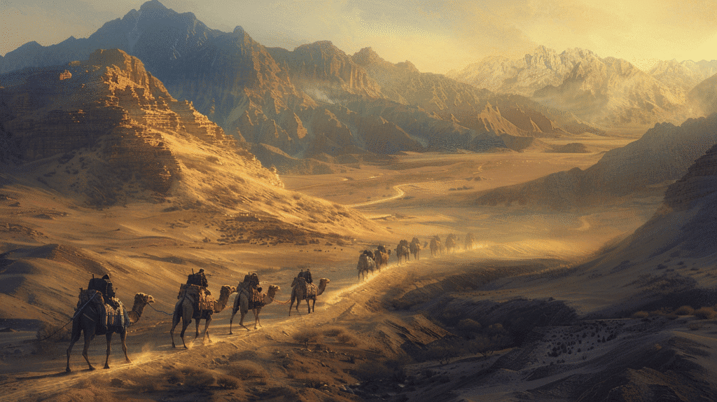
The Bactrian Camel: Two-humped camels from Central Asia were essential technology for desert trade:
- Water storage: Can survive 10-15 days without water (humans: 3-4 days)
- Load capacity: Carry 400-600 pounds
- Endurance: Travel 25-30 miles daily through harsh terrain
- Climate adaptation: Thick wool for cold, can tolerate heat, broad feet for sand
- Navigation: Some evidence camels could sense water sources
Caravan Organization:
- Size: Safety in numbers; large caravans (100+ camels common, sometimes 1,000+)
- Guides: Local expertise essential for navigation, water locations, timing
- Night travel: Summer desert crossings often at night to avoid heat
- Seasonal timing: Avoiding summer extremes and winter cold when possible
Supplies Required:
- Water in leather bags or goatskins
- Dried foods (dates, grains, dried meat)
- Fodder for animals
- Tents and shelter materials
- Weapons for defense
- Trade goods packed to withstand journey
The Mountains: Nature’s Barriers and Corridors
While deserts tested endurance, mountain ranges presented different challenges—and shaped Silk Road geography perhaps more profoundly than any other terrain type.
The Tianshan Mountains: Dividing and Connecting
The Tianshan (“Celestial Mountains”) stretch 1,500+ miles across Central Asia:
Geographic Characteristics:
- Height: Peaks reaching 24,000+ feet (Khan Tengri: 22,949 feet)
- Glaciers: Extensive permanent ice feeding oases below
- Valleys: Fertile mountain valleys providing grassland for nomadic herders
- Passes: Several crossable passes, though challenging
Silk Road Role:
- Natural boundary: Separating Taklamakan Basin from Kazakhstan steppes
- Water source: Snowmelt sustaining northern route oases
- Pasture: Alpine meadows supporting animals and nomadic economies
- Barrier: Limiting communication between routes on either side
Dzungarian Gap: The low pass between Tianshan and Altai Mountains provided:
- Easiest crossing: Between Central Asian steppes and Chinese borderlands
- Invasion route: Historically used by nomadic groups moving eastward
- Alternative trade route: Avoiding Taklamakan entirely
The Pamir Mountains: The Roof of the World
The Pamir Mountains, where several great ranges meet, were called “Bam-i-Dunya” (Roof of the World) and represented perhaps the Silk Road’s most formidable barrier:
Geographic Characteristics:
- Height: Peaks exceeding 24,000 feet; average elevation 13,000+ feet
- Location: Junction of Tianshan, Kunlun, Karakoram, and Hindu Kush ranges
- Climate: Extreme cold, thin air, unpredictable weather
- Glaciers: Extensive ice and snow year-round at higher elevations
Challenges for Travelers:
- Altitude sickness: Severe oxygen deprivation above 12,000 feet
- Cold: Temperatures well below freezing even in summer at high passes
- Avalanches: Snow and ice making travel dangerous
- Limited food: Little vegetation at high altitudes
- Narrow trails: Precipitous paths where single misstep meant death
Marco Polo’s Account: The Venetian traveler described the Pamirs vividly:
- Fire burns less brightly (due to thin air)
- Food cooks poorly (due to lower boiling point at altitude)
- Twelve days crossing with no habitation
- Such extreme cold that travelers reported diminished fire heat
Strategic Passes:
- Wakhan Corridor: Narrow valley between Pamir and Hindu Kush
- Torugart Pass: Connecting Kashgar to Kyrgyz steppes (altitude: 12,300 feet)
- Irkeshtam Pass: Alternative route from Kashgar westward
The Hindu Kush and Karakoram: Southern Mountain Barriers
These ranges created the geographic boundary between Central Asia and South Asia:
Hindu Kush (“Hindu Killer”—possibly referring to Indian slaves perishing during crossing):
- Extends 500+ miles from Afghanistan through Pakistan
- Peaks reaching 25,000+ feet
- Multiple passes connecting to South Asia
Karakoram (“Black Gravel”):
- Contains K2 (world’s second-highest peak: 28,251 feet)
- Some of world’s longest glaciers outside polar regions
- Extremely rugged, difficult terrain
The Khyber Pass: Most famous South Asian connection:
- Elevation: Relatively low (3,500 feet) compared to other mountain passes
- Length: Approximately 30 miles through Hindu Kush
- Location: Connecting Afghanistan and Pakistan (historically India)
- Historical significance: Used by countless armies (Alexander the Great, Genghis Khan, various Indian and Persian forces)
- Trade importance: Gateway for goods moving between Central Asia, Persia, and South Asia
Other Significant Passes:
- Salang Pass (Afghanistan): 11,000+ feet
- Khunjerab Pass (Pakistan-China border): 15,400 feet—one of world’s highest paved international borders
- Baroghil Pass (Afghanistan-Pakistan): Connecting Wakhan Corridor
Mountains as Cultural Boundaries
Mountain ranges didn’t just obstruct physical movement—they created cultural boundaries:
Linguistic divisions: Mountains separating language families (Sino-Tibetan, Indo-European, Turkic, Altaic).
Religious boundaries: Buddhism spreading through certain passes while Islam took different routes.
Genetic isolation: Mountain populations showing distinct genetic markers due to limited gene flow.
Architectural styles: Building techniques adapted to specific mountain environments (timber in forested ranges, stone in barren highlands).
Mountain Benefits: Not Just Barriers
Despite challenges, mountains provided crucial advantages:
Water: Snowmelt from mountains sustained oases and river valley civilizations.
Defensive positions: Mountain kingdoms difficult to conquer (Afghanistan’s resistance to empires partially geographic).
Mineral resources: Mountains often contained valuable minerals, gems, and metals.
Pasture: Alpine meadows providing summer grazing for nomadic herders.
Timber: Forested mountain slopes providing construction materials.
Central Asia: The Heart of the Silk Road
Once travelers negotiated China’s deserts and mountains, they entered Central Asia—a region of vast steppes, fertile valleys, and prosperous cities that became the Silk Road’s geographic and cultural heart.
The Steppe: Grassland Corridor
The Eurasian Steppe stretches from Hungary to Manchuria—5,000+ miles of grassland providing:
Geographic Characteristics:
- Terrain: Rolling plains with minimal trees, dominated by grasses
- Climate: Continental—cold winters, warm summers, moderate precipitation (more than deserts, less than forests)
- Rivers: Major rivers (Amu Darya, Syr Darya, others) creating fertile valleys
Nomadic Culture: Steppe geography created distinctive pastoral nomadic lifestyle:
- Mobility: Following seasonal pastures with herds (horses, sheep, cattle, camels)
- Military prowess: Horsemanship and mounted archery making steppe peoples formidable warriors
- Trade facilitation: Nomads protecting and taxing caravans, providing guides and animals
- Cultural transmission: Nomadic movement spreading ideas and technologies
Silk Road Implications:
- Northern routes: Crossing steppes offered easier travel than southern mountain/desert routes
- Nomadic empires: Groups like Xiongnu, Huns, Turks, Mongols alternatively threatening or facilitating trade
- Dual economy: Sedentary oasis cities coexisting with mobile pastoralists in symbiotic relationships
The Oasis Cities: Central Asian Jewels
Central Asia’s most famous cities were oasis settlements in fertile river valleys, becoming legendary centers of commerce, learning, and culture:
Samarkand (Sogdia):
- Geographic position: On Zarafshan River at convergence of routes from China, India, Persia
- Cultural crossroads: Persian, Turkic, Chinese influences creating unique synthesis
- Architectural glory: Registan Square, Bibi-Khanym Mosque, Shah-i-Zinda necropolis exemplifying Islamic architecture
- Tamerlane’s capital: 14th-century conqueror made Samarkand Central Asia’s most magnificent city
- Scholarly center: Astronomy, mathematics, literature flourishing
Bukhara:
- “Noble Bukhara”: Traditional epithet reflecting prestige
- Islamic learning: Over 200 madrasas at height, major center of Islamic scholarship
- Persian culture: Predominantly Persian-speaking despite Turkic political control
- Trade center: Silk, carpets, metalwork, and other goods exchanged
- Architectural heritage: Well-preserved medieval Islamic architecture
Merv (Mary, Turkmenistan):
- Ancient oasis: One of Central Asia’s oldest urban centers
- Geographic advantage: On Murghab River in otherwise arid region
- Size: Possibly world’s largest city in 12th century (500,000+ inhabitants)
- Destruction: Devastated by Mongol invasion 1221, never fully recovered
- Multiple cities: Successive cities built on same site across millennia
Tashkent:
- Modern capital: Now Uzbekistan’s capital and Central Asia’s largest city
- Geographic position: On Chirchiq River, connecting steppes to mountains
- Market center: Historically important trading hub
- Chinese influence: Closer to China than other major Central Asian cities
The Sogdians: Merchants of the Silk Road
The Sogdian people, inhabiting river valleys of modern Uzbekistan and Tajikistan, became the Silk Road’s most important merchants:
Geographic Advantages:
- Central position: Halfway between China and Mediterranean
- Linguistic skills: Sogdian language became lingua franca of Silk Road trade
- Network establishment: Sogdian trading colonies throughout route (from China to Black Sea)
- Cultural adaptability: Adopting customs of various regions while maintaining identity
Commercial Role:
- Intermediaries: Connecting Chinese and western merchants
- Banking: Early forms of credit and money transfer
- Caravanserais: Establishing lodging and warehousing facilities
- Information: Gathering intelligence about markets, routes, political situations
Cultural Transmission:
- Buddhism to China: Sogdian monks translating Buddhist texts into Chinese
- Artistic influence: Sogdian artistic motifs spreading along trade routes
- Agricultural transfers: Introducing crops (grapes, alfalfa) between regions
Rivers: Life in Arid Lands
Central Asian rivers provided lifelines in otherwise arid regions:
Amu Darya (ancient Oxus):
- Afghanistan-Tajikistan border, flowing through Uzbekistan and Turkmenistan
- Historically flowed to Aral Sea (now largely desiccated)
- Sustained major civilizations (Bactria, Khorezm)
Syr Darya (ancient Jaxartes):
- Rising in Tianshan, flowing through Kazakhstan
- Also historically fed Aral Sea
- Formed ancient boundary between settled and nomadic zones
Zarafshan:
- “Gold-strewer” in Persian
- Sustained Samarkand and Bukhara
- Never reaches sea, disappearing into desert
These rivers’ geographic constraint—flowing through arid lands with limited tributaries—meant that controlling their valleys meant controlling trade, agriculture, and power. The eventual Soviet-era diversion of these rivers for cotton irrigation has created the Aral Sea ecological disaster—one of history’s worst environmental catastrophes, demonstrating how geographic manipulation can have devastating consequences.
The Middle Eastern Connection: Crossroads of Continents
As Silk Road routes entered the Middle East, geography shifted dramatically, and routes multiplied as they approached Mediterranean destinations.
The Iranian Plateau: High Road to the West
Persia (Iran) occupied a strategic geographic position between Central Asia, South Asia, Mesopotamia, and the Mediterranean:
Geographic Characteristics:
- Elevation: High plateau (3,000-5,000 feet) surrounded by mountains (Zagros, Elburz, Hindu Kush)
- Climate: Arid to semi-arid, with greater rainfall in mountains
- Interior basins: Some with salt deserts (Dasht-e Kavir, Dasht-e Lut)
- Oases and river valleys: Supporting settlements and agriculture
Silk Road Routes Through Persia:
- Northern route: Through Khorasan region (Mashhad, Nishapur) connecting to Caspian Sea region
- Central route: Through central plateau cities (Rey/Tehran, Hamadan) to Mesopotamia
- Southern route: Through Kerman and Fars provinces connecting to Persian Gulf ports
Persian Cities:
- Ctesiphon (near Baghdad): Sassanian Persian capital, major trading center
- Rey/Tehran: Northern gateway between Central Asia and Mesopotamia
- Isfahan: Central Persian hub with magnificent Islamic architecture
- Shiraz: Southern cultural and commercial center
Persian Cultural Influence:
- Language: Persian became prestige language of culture, diplomacy, and poetry across region
- Art: Persian miniature painting, carpet weaving, metalwork influencing far beyond borders
- Architecture: Distinctive Persian Islamic architecture (iwan, muqarnas, tilework)
- Religion: Zoroastrianism pre-Islamic, then major center of Islamic civilization
Mesopotamia: Between Two Rivers
The Tigris and Euphrates rivers created fertile crescent where some of history’s earliest civilizations arose:
Geographic Advantages:
- Fertile valleys: Rich alluvial soils from river flooding
- Central position: Connecting Persian Gulf to Mediterranean, Persia to Levant
- Agricultural surplus: Supporting large urban populations
- River transportation: Facilitating goods movement
Silk Road Cities:
- Baghdad: Founded 762 CE as Abbasid Caliphate capital, became medieval world’s greatest city (possibly 1 million+ inhabitants)
- Round City design: Revolutionary circular plan
- House of Wisdom: Library and translation center preserving Greek, Persian, Indian knowledge
- Commercial center: Converging trade routes from east, west, north, south
- Basra: Southern Iraqi port at Persian Gulf head, connecting maritime and overland routes
- Mosul: Northern Iraq, controlling Tigris crossings
Geographic Challenges:
- Flooding: Rivers’ unpredictable flooding requiring extensive irrigation works
- Salinization: Improper irrigation eventually degrading agricultural productivity
- Political instability: Central position making region contested by empires
The Levant: Gateway to the Mediterranean
As routes approached the Mediterranean, they entered the Levant—the coastal region of modern Syria, Lebanon, Israel/Palestine, and Jordan:
Damascus:
- Ancient oasis: Sustained by Barada River in otherwise arid region
- Strategic position: Where desert routes from east met coastal routes to Mediterranean
- Cultural continuity: Continuously inhabited for 5,000+ years
- Umayyad capital: Early Islamic caliphate centered here
- Trade goods: Famous for damascened steel, textiles, glass
Palmyra:
- Desert oasis: Mid-route between Mediterranean and Mesopotamia
- Wealthy city-state: Controlled desert trade routes, taxed caravans
- Zenobia’s capital: 3rd-century queen briefly challenged Rome
- Ruins: Spectacular remaining columns, temples testifying to past grandeur
- Geographic vulnerability: Isolated position making it vulnerable to shifts in trade routes
Mediterranean Ports:
- Antioch (Antakya, Turkey): Major Hellenistic and Roman city where overland routes met maritime shipping
- Tyre and Sidon (Lebanon): Ancient Phoenician ports continuing as trading centers
- Alexandria (Egypt): Major Mediterranean port connecting to Red Sea and Indian Ocean via Nile and canal systems
Geographic Routes to Mediterranean
Multiple routes connected interior to coast:
- Syrian Desert route: Through Palmyra to Syrian coast
- Northern route: Through Anatolia (Turkey) to Black Sea or Aegean ports
- Southern route: Through Jordan and Sinai to Egyptian ports
- Via Nile: Goods traveling through Red Sea to Nile then Mediterranean
This multiplication of routes in the west contrasted with eastern concentration through Chinese Hexi Corridor—reflecting geographic differences (fewer barriers in west, more route options).
Maritime Silk Routes: The Sea Connection
While overland routes are better known, maritime Silk Roads across the Indian Ocean were equally important, complementing land trade and sometimes offering superior economics for bulk goods.
Geographic Advantages of Sea Routes
Lower Transportation Costs: Ships could carry far more cargo than camel caravans at lower per-unit costs—a single large dhow might carry as much as 1,000 camels.
Avoid Land Barriers: Maritime routes bypassed Central Asian deserts and mountains entirely, though presenting different dangers (storms, pirates, reefs).
Monsoon Winds: Seasonal wind patterns provided reliable propulsion:
- Summer monsoon (April-September): Southwest winds enabling sailing from Arabia/Africa to India and Southeast Asia
- Winter monsoon (October-March): Northeast winds enabling return voyages
Connecting Distant Regions: Maritime routes linked:
- East Asian ports (Guangzhou, Quanzhou, others)
- Southeast Asian ports (Malacca, Palembang, others)
- South Asian ports (Calicut, Cambay, Colombo)
- Arabian ports (Aden, Muscat, Hormuz)
- East African ports (Mogadishu, Kilwa, Zanzibar)
Major Maritime Silk Road Ports
Guangzhou (Canton):
- Geographic position: Pearl River delta providing access to Chinese interior
- Foreign quarter: Substantial Arab, Persian, and Southeast Asian merchant communities
- Trade goods: Silk, porcelain, tea exported; spices, incense, precious stones imported
Quanzhou (Zayton):
- Medieval prominence: Marco Polo called it one of world’s greatest ports
- Cosmopolitan: Muslim, Hindu, Christian communities alongside Chinese
- Shipbuilding: Major center of Chinese maritime technology
Calicut (Kozhikode, India):
- Spice center: Pepper and other spices exported worldwide
- Hindu kingdom: Powerful Zamorin rulers controlling Malabar Coast trade
- Portuguese arrival: Vasco da Gama reached here 1498, beginning European maritime dominance
Hormuz (Persian Gulf):
- Strategic strait: Controlling entrance to Persian Gulf
- Trans-shipment hub: Connecting Indian Ocean trade to Persian and Mesopotamian overland routes
- Portuguese control: Conquered 1507, exemplifying European penetration of Asian trade
Malacca:
- Geographic chokepoint: Controlling strait between Indian and Pacific Oceans
- Entrepôt: Goods from China, Southeast Asia, India, Arabia converging
- Cultural diversity: Malay, Chinese, Indian, Arab, and later European merchants
- Sultanate power: 15th-century Islamic sultanate at height of influence
Maritime Technologies
Ship Types:
- Chinese junks: Multi-masted vessels with watertight bulkheads, stern-mounted rudders—technologically advanced
- Arab dhows: Lateen-rigged ships well-suited to monsoon sailing
- Indian vessels: Various regional designs adapted to local conditions
Navigation:
- Celestial navigation: Using stars, particularly Polaris in Northern Hemisphere
- Compass: Chinese invention spreading via maritime routes
- Portolan charts: Maps showing ports and coastal features
- Local knowledge: Pilots with detailed understanding of winds, currents, dangers
Maritime-Overland Integration
Sea and land routes were complementary rather than competitive:
- Bulk goods (ceramics, spices) favored sea transport
- High-value, low-volume goods (silk, precious stones) could justify overland transport’s higher costs
- Different goods traded on different routes
- Some merchants specialized in one route type; others integrated both
Geography and Cultural Exchange: How Terrain Shaped Civilization
The Silk Road’s diverse geography didn’t just move goods—it profoundly influenced how cultures encountered and influenced each other.
Buddhism’s Geographic Journey
Buddhism spread from India to East Asia primarily via Silk Road routes, with geography shaping this transmission:
Mountain Passes as Gateways: Buddhism entered China through:
- Karakoram passes: From Kashmir to Xinjiang
- Central Asian oases: Buddhist kingdoms (Kucha, Khotan) serving as intermediaries
- Translation centers: Dunhuang, Chang’an where Indian texts translated to Chinese
Oasis Cities as Cultural Incubators:
- Monks traveling with caravans, establishing monasteries at oasis cities
- Cave complexes (Mogao, Bezeklik) becoming artistic and scholarly centers
- Local rulers patronizing Buddhism for prestige and trade benefits
Adaptation to Geography:
- Cave temples: In arid regions lacking timber, caves carved into cliffs
- Architectural styles: Indian stupas, Central Asian forms, Chinese pagodas showing geographic cultural synthesis
- Iconography: Greco-Buddhist art from Gandhara showing Hellenistic influence traveling through Central Asia
Islam’s Expansion Along Trade Routes
Islam spread along Silk Road routes after 7th century:
Geographic Pattern:
- Rapid conquest: Arab armies following trade routes conquered Persia, Central Asia
- Merchant transmission: Muslim traders bringing Islam to oases and ports
- Strategic conversions: Ruling elites converting for political and commercial advantages
- Urban centers: Islam strongest in trading cities; rural/nomadic areas converting more slowly
Geographic Limits:
- Chinese border: Islam stopped at edge of Chinese cultural sphere (Xinjiang remained Muslim; interior China did not convert)
- Southeast Asian pattern: Islam spread via maritime routes to island Southeast Asia but less successfully in mainland
- Steppe nomads: Many Turkic and Mongol peoples eventually converting, transforming Central Asian cultural landscape
Artistic and Technological Exchanges
Greco-Buddhist Art:
- Alexander the Great’s conquests bringing Hellenistic influences to Central Asia and India
- Greek sculptural techniques applied to Buddhist subjects
- Geographic spread: From Gandhara through Central Asian oases to China
Paper Technology:
- Chinese invention reaching Central Asia when Tang Chinese prisoners captured at Talas (751 CE) by Abbasids
- Geographic diffusion: Central Asia → Middle East → Europe
- Replacing papyrus and parchment, transforming literacy
Gunpowder:
- Chinese invention traveling westward
- Military technology spreading along routes
- Eventually transforming warfare globally
Agricultural Exchanges:
- Eastward: Grapes, alfalfa, pomegranates from Central Asia/Persia to China
- Westward: Peaches, apricots from China to Mediterranean
- Geographic requirements: Crops adapted to new climates, sometimes limiting spread
The Black Death: Dark Side of Connectivity
The bubonic plague (1347-1353) demonstrated how geographic connectivity could transmit not just goods and ideas but also disease:
Geographic Spread:
- Originated in Central Asia or China
- Traveled along Silk Road trade routes westward
- Reached Black Sea ports via Mongol armies
- Maritime routes carried to Mediterranean and beyond
- Killed 30-60% of European population
Trade Network as Disease Vector: The very routes that enriched civilizations also enabled pandemic spread—geographic connectivity’s double edge.
Challenges of Silk Road Geography: Obstacles Travelers Faced
Beyond specific deserts and mountains, Silk Road travelers confronted cumulative geographic challenges that made journeys extraordinarily difficult:
Environmental Hazards
Deserts:
- Extreme heat causing dehydration and heat stroke
- Sandstorms burying trails and caravans
- Lack of water forcing rigid travel schedules
- Disorientation from monotonous landscape
- Mirages deceiving travelers
Mountains:
- Altitude sickness from thin air at high passes
- Avalanches and rockfalls
- Narrow trails where missteps meant death
- Extreme cold and frostbite
- Unpredictable weather
Rivers:
- Flash floods suddenly filling dry wadis
- Dangerous crossings (drowning risk)
- Seasonal variations affecting navigability
Wildlife Threats
Predators:
- Wolves and leopards in mountains
- Lions (historically) in some regions
- Snakes and scorpions in deserts
Disease Vectors:
- Mosquitoes carrying malaria in river valleys
- Fleas and lice spreading plague and typhus
- Parasites in contaminated water
Human Dangers
Bandits and Raiders:
- Geographic chokepoints (passes, oases) creating ambush opportunities
- Isolated stretches where caravans vulnerable
- Nomadic groups alternating between protecting and raiding caravans
Political Instability:
- Wars closing routes or making them dangerous
- Border conflicts trapping travelers
- Arbitrary taxation or confiscation by local rulers
Cultural Barriers:
- Language differences complicating negotiations
- Different legal systems creating confusion
- Religious tensions occasionally erupting into violence
Logistical Challenges
Navigation:
- Limited maps, often inaccurate
- Natural landmarks shifting (sand dunes moving)
- Reliance on local guides (expensive, sometimes unreliable)
Supplies:
- Carrying sufficient water and food
- Finding fodder for animals
- Repairing equipment (saddles, packs, shoes)
Seasonal Constraints:
- Winter closing mountain passes
- Summer heat making deserts even more dangerous
- Monsoon timing dictating maritime schedules
The Psychological Toll
Isolation: Months away from home, uncertain whether alive or dead.
Monotony: Days of identical desert or steppe landscape.
Fear: Constant awareness of dangers.
Uncertainty: Never knowing if reaching destination or dying en route.
These cumulative challenges meant that Silk Road trade required extraordinary courage, careful planning, substantial capital, and often simple luck.
The Lasting Legacy: Silk Road Geography’s Modern Relevance
Though the classic Silk Road ceased functioning centuries ago, its geographic logic continues influencing modern infrastructure and geopolitics.
Modern Transportation Following Ancient Paths
Railways: Many 19th-20th century railways follow Silk Road routes:
- Trans-Siberian Railway: Northern steppe route connecting Europe and East Asia
- Chinese railways: Extending through Hexi Corridor into Xinjiang
- Central Asian networks: Connecting former Soviet republics along traditional routes
Highways: Modern road networks often parallel ancient paths:
- Karakoram Highway: Pakistan-China, one of world’s highest paved roads, following ancient passes
- Central Asian highways: Connecting capitals through traditional oasis chains
Pipelines: Oil and gas pipelines from Central Asia follow geographic logic similar to trade routes—avoiding worst mountains and deserts while connecting resource sources to markets.
China’s Belt and Road Initiative: Silk Road Reborn?
China’s massive infrastructure project explicitly invokes Silk Road heritage:
Geographic Scope:
- Overland routes: Recreating historic paths through Central Asia to Europe
- Maritime routes: Following Indian Ocean sea lanes to Mediterranean
- Investment: Ports, railways, highways, pipelines across dozens of countries
Similarities to Historic Silk Road:
- Following similar geographic corridors (Hexi Corridor, Central Asian oases, Persian routes)
- Connecting Chinese economy to western markets
- Infrastructure investment facilitating trade
Differences:
- Modern technology overcoming some historic barriers (tunnels through mountains, crossing deserts directly)
- Political rather than purely commercial motivations
- Chinese state-directed vs. historic merchant-driven
- Speed and scale unprecedented
Geographic Challenges Persist:
- Central Asian political instability
- Difficult terrain requiring expensive infrastructure
- Maritime route chokepoints (Malacca, Hormuz) creating vulnerabilities
Tourism: Geographic Heritage as Economic Resource
Many Silk Road cities and sites now attract tourists, creating heritage economies:
- UNESCO World Heritage Sites: Samarkand, Bukhara, Dunhuang Caves, Palmyra (destroyed), others
- Tourism routes: Organized tours following ancient paths
- Cultural preservation: Economic incentives protecting historic sites
- Local economies: Tourism providing income in otherwise economically marginal regions
Geographic Challenges: Remote locations making access difficult, climate extremes affecting tourism seasons, political instability in some regions deterring visitors.
Geopolitical Competition: The Silk Road’s Shadow
Modern competition for influence in Central Asia reflects historic geographic importance:
- Russia: Viewing Central Asia as traditional sphere of influence
- China: Expanding economic and political influence via BRI
- United States: Seeking to maintain influence, concerned about Chinese expansion
- Regional powers (Turkey, Iran, India): Pursuing own interests
- Energy resources: Competition for Central Asian oil and gas adding modern dimension
The region’s geographic position—between major powers, containing energy resources, controlling potential transit routes—ensures continued strategic relevance.
Final Thoughts: Geography of the Silk Road
The Silk Road was as much a geographic phenomenon as a cultural or commercial one. Its mountains, deserts, steppes, and seas didn’t just provide backdrop—they fundamentally determined where trade could flow, how civilizations interacted, which cities prospered, and how ideas spread across continents.
Geography dictated that routes must pass through the Hexi Corridor, that caravans must skirt rather than cross the Taklamakan, that passes through the Pamirs would be deadly dangerous, that oases would become wealthy trading centers, that monsoons would determine maritime schedules, and that Central Asia would become the inevitable crossroads where East and West met.
The merchants, monks, soldiers, and adventurers who traveled these routes were responding to geographic realities—finding paths of least resistance through formidable landscapes, taking advantage of water sources, timing journeys to seasonal conditions, and adapting their strategies to terrain. Their choices, aggregated across centuries and thousands of individual journeys, created the patterns we call the Silk Road.
Understanding this geography reveals fundamental truths about human civilization: that trade follows feasible paths rather than optimal ones, that physical barriers create cultural boundaries even as gaps in those barriers become cultural mixing zones, that controlling strategic geographic points translates directly to wealth and power, and that humanity’s ability to overcome geographic obstacles—while real—remains constrained by planetary realities.
From the shifting sands of the Taklamakan to the frozen heights of the Pamirs, from the fertile oases of Central Asia to the ancient ports of the Mediterranean, the Silk Road demonstrates how landscapes shape history just as much as human agency. The routes may no longer carry silk-laden caravans, but the geographic logic that created them continues influencing how goods, people, and ideas move across our interconnected world.
The Silk Road stands as testament to human determination to connect across vast distances despite nature’s obstacles, and as reminder that geography—patient, persistent, and powerful—remains the foundation upon which all human endeavors, from ancient trade routes to modern infrastructure, must ultimately be built.