Table of Contents
The World’s Longest Rivers and Why They Matter: The Arteries of Civilization
Introduction: Rivers That Changed the World
Stand on the banks of the Amazon River in Brazil, and you’re witnessing an astonishing sight: a river so vast it discharges 209,000 cubic meters of water into the Atlantic Ocean every second—more than the next seven largest rivers combined. During flood season, the Amazon can be up to 30 miles wide in places, creating what locals call a “river sea” where you can’t see from one shore to the other.
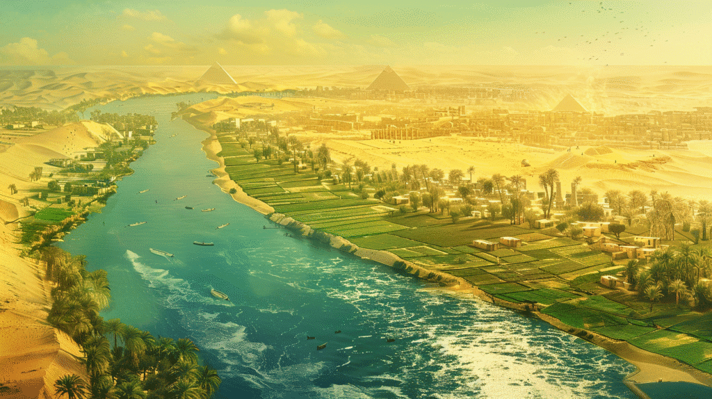
Or travel to Egypt, where 95% of the population lives within a few miles of a single river—the Nile. For over 5,000 years, this ribbon of water flowing through one of Earth’s harshest deserts has been the difference between life and death, abundance and starvation, civilization and wilderness. Ancient Egyptians called their country “Kemet” (the black land) for the rich, dark soil deposited by annual Nile floods, while the surrounding desert was “Deshret” (the red land)—lifeless and inhospitable.
Rivers are the lifeblood of civilizations—flowing highways that have shaped human history, supported ecosystems, and sustained life for millennia. From the dense rainforests of the Amazon Basin to the arid deserts of Africa, from the industrial heartlands of China to the agricultural centers of North America, the world’s longest rivers play vital roles in connecting continents, cultures, and climates.
But what makes these mighty waterways so important? How do they continue shaping our world today? And why, despite their immense power, are many of them under unprecedented threat?
This comprehensive guide explores Earth’s greatest rivers, examining how river length is measured and why it’s surprisingly controversial, the characteristics and significance of each major river, the profound ways rivers shape ecosystems, climate, and human civilization, the critical environmental challenges threatening these vital waterways, and why protecting rivers matters for our collective future.
Measuring River Length: Surprisingly Complex
Before exploring individual rivers, it’s important to understand why determining “the world’s longest river” isn’t as straightforward as it seems.
The Challenge of Defining River Length
River length is measured from source to mouth—from where the river begins to where it empties into an ocean, sea, or lake. However, this seemingly simple definition hides enormous complexity:
Source Determination Challenges
Where does a river actually begin?
Multiple Tributaries: Most major rivers have numerous tributaries, each potentially claiming to be the “true” source. Which tributary counts as the main channel? The longest? The one carrying the most water? The one locals consider the source?
Seasonal Variations: Some upper tributaries flow only seasonally. Should year-round flow be required?
Glacier Sources: Many rivers originate from glaciers. As glaciers retreat due to climate change, source locations shift, literally changing river length over time.
Underground Sources: Some rivers have underground sections near their sources, complicating measurement.
Example: The Amazon: For decades, geographers debated whether the Amazon’s source was in Peru (Río Apurímac) or Ecuador. Recent satellite mapping identified the Mantaro River in Peru as the farthest source, but disputes continue.
Mouth Definition Complexities
Where does a river actually end?
Deltas: Rivers often split into multiple distributary channels forming deltas. Which channel determines the mouth location? The longest? The main shipping channel?
Estuaries: Where rivers meet the sea through wide estuaries, defining the exact mouth location becomes subjective.
Tidal Influence: Should river length include areas subject to tidal influence, or only freshwater sections?
Example: The Nile: The Nile Delta has multiple distributaries. Historical measurements used different delta branches, creating length variations.
Measurement Technology Evolution
How measurement affects length:
Mapping Improvements: Satellite imagery and GPS technology have dramatically improved mapping accuracy, leading to revised length estimates for many rivers.
Resolution Effects: Higher-resolution mapping captures more meanders and curves, potentially increasing measured length. A river measured on a low-resolution map appears shorter than the same river measured with high-resolution data.
International Standards: Lack of universal standards means different organizations may report different lengths for the same river.
The Great Debate: Nile vs. Amazon
The question of “world’s longest river” has traditionally generated debate between the Nile and Amazon:
Traditional View: The Nile was long considered definitively the longest at approximately 6,650 km (4,130 miles).
Amazon Challenge: Measurements in the 1990s-2000s, using improved technology and including the Mantaro-Apurímac tributary system, suggested the Amazon might be longer at 6,800 km (4,225 miles) or more.
Current Consensus: Most authorities still list the Nile as longest, though acknowledging the Amazon is extremely close and potentially longer depending on measurement methodology.
Volume vs. Length: Regardless of length, the Amazon is indisputably the largest river by discharge volume—carrying more water than the next seven largest rivers combined.
This controversy illustrates that river rankings aren’t as definitive as they might appear, with measurement methodology significantly affecting results.
The World’s Longest Rivers: Giants of Geography
Let’s explore the characteristics, significance, and unique features of Earth’s mightiest rivers.
1. The Nile River: Desert Lifeline
Length: Approximately 6,650 km (4,130 miles) Countries: 11 countries including Egypt, Sudan, Uganda, Ethiopia, Tanzania, Kenya, Rwanda, Burundi, Eritrea, Democratic Republic of Congo, South Sudan Discharge: 2,830 cubic meters per second Basin Area: 3.4 million km²
Geography and Characteristics
The Nile flows northward—unusual among major rivers—through northeastern Africa, traversing diverse landscapes from equatorial highlands to Mediterranean coast:
Sources: The Nile has two main tributaries:
- White Nile: Originates from Lake Victoria (fed by rivers from Rwanda and Burundi), providing base flow
- Blue Nile: Begins at Lake Tana in Ethiopia, contributing most of the water and virtually all the sediment during flood season
Course: The river flows through Lake Victoria, descends through East African highlands, crosses vast Sudanese plains, and cuts through Egyptian desert before spreading into the Nile Delta and entering the Mediterranean Sea.
No Tributaries in Lower Reaches: Remarkably, the Nile receives no tributaries for its last 3,000 km through Sudan and Egypt—just a ribbon of water flowing through desert.
Historical Significance
Cradle of Civilization: Ancient Egyptian civilization depended entirely on the Nile. The annual flood cycle deposited nutrient-rich silt, enabling agriculture in an otherwise desert environment.
Predictable Flooding: Unlike rivers with unpredictable floods, the Nile flooded annually with remarkable consistency (before modern damming), allowing Egyptians to develop sophisticated agricultural calendars.
Transportation Highway: The Nile connected Upper and Lower Egypt, enabling trade, communication, and political unity.
Cultural Impact: Egyptian religion, architecture, and society all revolved around the river. The Egyptian calendar aligned with flood cycles, and myths incorporated the river’s life-giving properties.
Modern Challenges
Population Pressure: Over 300 million people depend on the Nile Basin, with populations growing rapidly.
Water Scarcity: Demand exceeds supply, creating tensions among upstream and downstream nations.
Grand Ethiopian Renaissance Dam: Ethiopia’s massive dam project on the Blue Nile has created diplomatic tensions with downstream Egypt and Sudan over water allocation.
Pollution: Industrial waste, agricultural runoff, and sewage increasingly pollute the river.
Climate Change: Altered rainfall patterns and glacier retreat in source regions threaten water supplies.
2. The Amazon River: The Mighty Jungle Giant
Length: Approximately 6,400-6,800 km (4,000-4,225 miles), depending on source definition Countries: Brazil (60% of basin), Peru, Colombia, Venezuela, Ecuador, Bolivia, Guyana, Suriname, French Guiana Discharge: 209,000 cubic meters per second (average) Basin Area: 7.0 million km² (40% of South America)
Unmatched Statistics
The Amazon dominates all river superlatives related to volume, drainage, and impact:
Discharge Volume: Accounts for approximately 20% of all freshwater entering Earth’s oceans from rivers. During peak flow, discharge can exceed 300,000 cubic meters per second.
No Bridges: Despite being one of the world’s major rivers, the Amazon has no bridges across its entire length—a testament to its width, depth, remote location, and limited transportation need given sparse population.
Width Variations: During dry season, the Amazon can be 2-6 miles wide. During flood season, it can expand to 30 miles wide in places, inundating vast areas of rainforest.
Depth: In places, the Amazon exceeds 100 meters (330 feet) deep—deep enough to accommodate ocean-going vessels more than 1,000 miles inland to Iquitos, Peru.
Tributaries: Over 1,100 tributaries, with 17 longer than 1,000 km (620 miles).
Ecological Importance
Rainforest Support: The Amazon River system is intimately connected with the Amazon Rainforest—the world’s largest tropical rainforest and most biodiverse terrestrial ecosystem.
Aquatic Biodiversity: Contains approximately 3,000 known fish species (more than the entire Atlantic Ocean), with new species still being discovered regularly.
Carbon Storage: The Amazon Basin stores massive amounts of carbon in both forest biomass and river sediments, playing a crucial role in global carbon cycling and climate regulation.
Ocean Influence: Amazon discharge creates a plume of freshwater extending hundreds of kilometers into the Atlantic Ocean, affecting marine ecosystems and ocean chemistry.
Nutrient Transport: The river transports approximately 1.3 billion tons of sediment annually, much derived from Andean erosion, distributing nutrients throughout the basin.
Threats and Concerns
Deforestation: Amazon Rainforest deforestation accelerates, driven by cattle ranching, soy cultivation, and logging, affecting river hydrology and sediment loads.
Dam Construction: Proposed and existing dams on Amazon tributaries threaten aquatic ecosystems, particularly migratory fish species.
Mercury Pollution: Gold mining introduces mercury into river systems, contaminating fish and endangering human health.
Climate Change: Increasing temperatures and altered rainfall patterns may push the Amazon ecosystem toward a tipping point, potentially transforming rainforest into savanna.
3. The Yangtze River: China’s Flowing Dragon
Length: Approximately 6,300 km (3,917 miles) Countries: China (entirely within) Discharge: 30,166 cubic meters per second Basin Area: 1.8 million km²
Geography and Development
The Yangtze flows from the Tibetan Plateau across China to the East China Sea near Shanghai:
Source: Begins at 5,170 meters elevation in the Tanggula Mountains on the Tibetan Plateau.
Course: Descends through deep gorges (including the famous Three Gorges), flows across China’s industrial heartland, and spreads into a vast delta.
Population: Over 400 million people—about one-third of China’s population—live in the Yangtze River Basin, making it the world’s most populous river basin.
Economic Powerhouse
Industrial Corridor: The Yangtze Basin generates approximately 40% of China’s GDP, hosting major industrial cities including Shanghai, Wuhan, Chongqing, and Nanjing.
Agricultural Production: The basin produces about 70% of China’s rice and accounts for significant portions of cotton, wheat, and other crops.
Transportation: The Yangtze serves as China’s primary inland waterway, with ocean-going vessels reaching Wuhan (1,000 km inland) and smaller vessels continuing much farther.
Three Gorges Dam: The world’s largest hydroelectric installation, generating over 100 billion kWh annually—equivalent to burning 50 million tons of coal. However, it also caused massive environmental and social impacts, displacing over 1.3 million people.
Environmental Challenges
Pollution: Decades of rapid industrialization have severely polluted the Yangtze, though recent cleanup efforts show improvement.
Biodiversity Loss: The Yangtze River dolphin (baiji) was declared functionally extinct in 2006—the first dolphin species driven to extinction by human activity. Other species like the Chinese sturgeon face similar threats.
Flood Control vs. Ecology: Extensive damming and channelization control floods but fragment aquatic habitats and alter natural flow patterns essential for ecosystem health.
4. Mississippi-Missouri River System: America’s Heartland Artery
Combined Length: Approximately 6,275 km (3,902 miles) Country: United States (98% of basin) Discharge: 16,792 cubic meters per second Basin Area: 3.2 million km² (about 40% of contiguous United States)
Continental Integration
The Mississippi-Missouri system drains the vast interior of North America:
Missouri River: The longest tributary at 3,767 km, originating in Montana’s Rocky Mountains.
Mississippi River: The main stem flows from Minnesota’s Lake Itasca to the Gulf of Mexico, joined by the Missouri near St. Louis and the Ohio River further downstream.
Tributary Network: Major tributaries include the Arkansas, Red, Ohio, Tennessee, and Illinois rivers, creating a transportation network connecting much of the U.S. interior.
Economic Significance
Agricultural Powerhouse: The basin encompasses America’s Corn Belt and much of its agricultural heartland, producing significant portions of U.S. corn, soybeans, wheat, and cotton.
Transportation: The Mississippi carries over 500 million tons of cargo annually—more than any other U.S. waterway—including grain, petroleum, coal, and manufactured goods. Barge transportation on the Mississippi is significantly cheaper per ton-mile than rail or truck transport.
Port of South Louisiana: Located on the lower Mississippi, it’s one of the world’s busiest ports by tonnage.
Environmental Concerns
Dead Zone: Agricultural runoff carries massive amounts of nitrogen and phosphorus into the Gulf of Mexico, creating a hypoxic “dead zone” the size of New Jersey where oxygen levels are too low to support most marine life.
Levees and Flooding: Extensive levee systems protect development but prevent natural flooding that replenished wetlands and distributed sediments, causing wetland loss and making floods more severe when levees fail.
Sediment Starvation: Dams on tributaries trap sediment that previously built and maintained the Mississippi Delta, which is now eroding and sinking at alarming rates—contributing to Louisiana’s coastal land loss crisis.
Invasive Species: The Mississippi serves as a highway for invasive species like Asian carp, which threaten to reach the Great Lakes.
5. Yenisei River: Siberian Giant
Length: Approximately 5,539 km (3,445 miles) Countries: Mongolia (source), Russia (vast majority) Discharge: 19,600 cubic meters per second Basin Area: 2.6 million km²
The Yenisei flows through remote Siberia from Mongolia to the Arctic Ocean, passing through diverse landscapes from mountain forests to taiga to tundra. As one of the world’s greatest Arctic rivers, the Yenisei significantly influences Arctic Ocean salinity and ice dynamics.
Characteristics: The river remains frozen 5-6 months annually. Its basin contains vast forests, significant mineral resources, and sparse human population. The Yenisei has been extensively dammed for hydroelectric power, with major impacts on downstream ecosystems.
Other Major Rivers: Brief Profiles
Yellow River (Huang He) (5,464 km / 3,395 miles): China’s “cradle of civilization,” historically vital to Chinese culture but also known as “China’s Sorrow” for devastating floods that killed millions. Carries massive sediment loads, giving the river its yellow color.
Ob-Irtysh River (5,410 km / 3,364 miles): Flows through Russia and Kazakhstan to the Arctic Ocean. The Ob River’s immense basin drains western Siberia.
Paraná River (4,880 km / 3,030 miles): South America’s second-longest river system, flowing through Brazil, Paraguay, and Argentina. Important for hydroelectric power and transportation.
Congo River (4,700 km / 2,920 miles): Africa’s second-longest river but the world’s deepest (over 220 meters in places). Second only to the Amazon in discharge volume. The Congo Basin contains the world’s second-largest rainforest.
Amur River (4,444 km / 2,763 miles): Forms much of the border between Russia and China. Important for sturgeon fisheries and regional transportation.
Why Rivers Matter: Far More Than Water Flow
Long rivers profoundly influence virtually every aspect of Earth systems and human civilization.
Life Support and Fresh Water
Drinking Water: Rivers provide fresh water for billions of people directly (through withdrawal) and indirectly (recharging aquifers).
Irrigation: River water enables agriculture in regions that would otherwise be too dry. The world’s major agricultural regions—from the Nile Delta to China’s rice paddies to North America’s corn belt—depend on river irrigation.
Ecosystem Support: Rivers provide water for countless terrestrial and aquatic ecosystems, supporting biodiversity far beyond the river channel itself.
Drought Buffer: During droughts, rivers become even more critical, often representing the only reliable water source.
Shapers of Civilizations
Rivers have determined where civilizations emerge, thrive, or collapse:
Ancient Civilizations: Nearly every ancient civilization emerged along major rivers:
- Egypt and the Nile
- Mesopotamia and the Tigris-Euphrates
- Indus Valley Civilization and the Indus River
- Chinese civilization and the Yellow River
- Nubia and the Nile
Urban Development: Major cities worldwide are located on rivers: London (Thames), Paris (Seine), Baghdad (Tigris), Delhi (Yamuna), Cairo (Nile), Shanghai (Yangtze), New York (Hudson), among countless others.
Political Boundaries: Rivers often define political boundaries, both facilitating governance (by creating natural borders) and causing conflicts (over water access and rights).
Cultural Identity: Rivers feature prominently in cultural identity, religion, art, and literature. The Ganges is sacred to Hindus, the Jordan holds religious significance for multiple faiths, and countless rivers feature in myths and traditions worldwide.
Transportation and Trade
Historical Importance: Before modern transportation, rivers were often the only practical means of moving bulk goods and people over long distances.
Continuing Relevance: River transportation remains economically important:
- Lower cost per ton-mile than rail or truck
- Lower environmental impact per ton-mile
- Essential for landlocked regions
- Crucial for bulk commodities (grain, coal, petroleum)
Infrastructure Development: Ports, bridges, and canals along rivers concentrate economic activity and enable regional integration.
Ecosystem Services and Biodiversity
Habitat Provision: Rivers and their floodplains support extraordinary biodiversity, hosting numerous endemic species found nowhere else.
Nutrient Transport: Rivers transport nutrients from land to sea, supporting both freshwater and marine food webs. River-borne nutrients fuel coastal fisheries feeding millions.
Sediment Distribution: River sediments build and maintain deltas, wetlands, and floodplains—among Earth’s most productive ecosystems.
Migration Corridors: Many species, particularly fish, use rivers as migration routes. Salmon returning from oceans to spawn in freshwater represent iconic examples.
Water Quality: Healthy river ecosystems filter pollutants, process nutrients, and maintain water quality through natural processes.
Climate Regulation
Global Water Cycle: Rivers represent crucial components of the global hydrological cycle, transporting water from land to oceans.
Heat Transport: River discharge affects ocean temperature and circulation patterns, influencing regional and global climate.
Carbon Cycling: Rivers transport dissolved and particulate organic carbon from land to oceans, playing significant roles in the global carbon cycle.
Local Climate: Large rivers create local climate effects, moderating temperatures and providing moisture for precipitation.
Energy Generation
Hydroelectric Power: Many of the world’s longest rivers have been dammed for hydroelectric generation:
- Three Gorges Dam (Yangtze): World’s largest power station
- Itaipu Dam (Paraná): One of the world’s largest hydroelectric facilities
- Grand Coulee Dam (Columbia River): Major U.S. power source
Clean Energy: Hydroelectric power provides renewable energy with lower greenhouse gas emissions than fossil fuels, though dams create other environmental impacts.
Energy Security: For countries with limited fossil fuel resources, hydroelectric power from rivers provides energy independence.
Environmental Threats: Rivers Under Pressure
Despite their importance, the world’s great rivers face unprecedented threats from human activity and climate change.
Over-Extraction and Flow Reduction
Agricultural Demand: Irrigation for agriculture consumes the majority of water withdrawn from rivers globally, with some rivers like the Colorado and Yellow River running dry in their lower reaches during certain seasons.
Urban Growth: Expanding cities withdraw increasing volumes for drinking water and industrial use.
Reduced Flows: Extraction reduces river flows, harming aquatic ecosystems and eliminating flooding that historically maintained floodplain ecosystems.
Examples: The Colorado River rarely reaches the Gulf of California anymore. The Yellow River frequently runs dry before reaching the sea. The Aral Sea, once fed by two major rivers, has shrunk to a fraction of its historical size due to irrigation withdrawals.
Pollution
Industrial Discharge: Factories discharge toxic chemicals, heavy metals, and heated water into rivers, harming aquatic life and making water unsafe for human use.
Agricultural Runoff: Fertilizers and pesticides wash into rivers, causing eutrophication (excess nutrient loading) that creates algal blooms and oxygen-depleted dead zones.
Sewage: Untreated or inadequately treated sewage introduces pathogens and nutrients.
Plastic Pollution: Rivers transport massive amounts of plastic waste to oceans, with major Asian rivers being primary sources of ocean plastic pollution.
Examples: The Ganges is heavily polluted by industrial waste and sewage. The Mississippi’s agricultural runoff creates a massive Gulf of Mexico dead zone. Many Chinese rivers suffered severe industrial pollution, though cleanup efforts show improvement.
Dams and Flow Alteration
Proliferation: Over 58,000 large dams exist globally, fragmenting virtually all major river systems.
Impacts:
- Habitat Fragmentation: Dams block fish migration and divide river ecosystems
- Sediment Trapping: Dams trap sediment, starving downstream areas and causing delta erosion
- Flow Alteration: Natural flood pulses essential for floodplain ecosystems are eliminated
- Temperature Changes: Dam releases can be colder or warmer than natural flows
- Methane Emissions: Reservoir vegetation decomposition can produce significant methane emissions
Examples: The Three Gorges Dam displaced over 1.3 million people and eliminated habitat for numerous species. Dams on the Mekong River threaten fisheries supporting tens of millions. Columbia River dams decimated legendary salmon runs.
Climate Change
Altered Precipitation: Climate change modifies rainfall patterns, causing some regions to receive more water and others less, making flows less predictable.
Glacier Retreat: Many major rivers—including the Ganges, Indus, Yangtze, and Mekong—depend on glacial meltwater. Himalayan glacier retreat threatens water supplies for over one billion people.
Increased Evaporation: Higher temperatures increase evaporation from rivers and reservoirs, reducing available water.
Extreme Events: Climate change intensifies both droughts and floods, creating challenges for water management.
Sea Level Rise: Rising seas cause saltwater intrusion into river deltas, threatening agriculture and freshwater supplies.
Habitat Loss and Biodiversity Decline
Wetland Drainage: Over 50% of the world’s wetlands have been drained for agriculture and development, eliminating crucial river-associated habitats.
Floodplain Development: Levees and development prevent rivers from accessing historical floodplains, eliminating habitat and natural processes.
Species Decline: Freshwater species populations have declined by an average of 83% since 1970—a more severe decline than for terrestrial or marine species.
Extinctions: Numerous species have gone extinct, including the Yangtze River dolphin, and many others face extinction threats.
Protecting Rivers: Essential Actions
Ensuring rivers remain healthy and functional requires comprehensive approaches:
Integrated Watershed Management
Whole-Basin Approach: Managing rivers requires considering entire watersheds rather than isolated sections, accounting for how upstream activities affect downstream conditions.
Stakeholder Coordination: Involving all stakeholders—governments, industries, farmers, indigenous peoples, environmental groups—in management decisions.
International Cooperation: For rivers crossing international boundaries, treaties and cooperation mechanisms are essential but often politically challenging.
Pollution Prevention and Treatment
Source Control: Reducing pollution at its source through cleaner industrial processes, sustainable agriculture, and improved waste management.
Wastewater Treatment: Investing in sewage treatment infrastructure to prevent untreated waste from entering rivers.
Agricultural Best Practices: Implementing practices that reduce fertilizer and pesticide runoff while maintaining productivity.
Monitoring: Establishing comprehensive water quality monitoring to detect pollution and track improvements.
Sustainable Water Allocation
Efficiency: Improving water use efficiency in agriculture (drip irrigation, precision farming), industry, and urban areas.
Environmental Flows: Ensuring rivers maintain sufficient flow to support ecosystems, not just human needs.
Water Rights: Establishing clear, sustainable water rights that balance competing uses.
Groundwater Management: Integrating groundwater and surface water management since they’re connected systems.
Dam Management and River Restoration
Dam Removal: Removing obsolete dams to restore river connectivity, with over 1,700 U.S. dams removed since 2000.
Environmental Flow Releases: Operating dams to release water in patterns that partially mimic natural flows.
Fish Passage: Installing fish ladders and other structures enabling fish migration past dams.
Floodplain Reconnection: Removing or setting back levees to reconnect rivers with floodplains where feasible.
Climate Adaptation
Flexible Management: Developing adaptive management approaches that can respond to changing conditions.
Nature-Based Solutions: Using wetland restoration, reforestation, and other natural approaches to improve water storage and quality.
Diversified Water Sources: Reducing dependence on single sources through diversification, including groundwater, desalination, and water reuse where appropriate.
Conclusion: Rivers Connect Us All
The world’s longest rivers are far more than geographical features marked on maps or impressive statistics in reference books. They are living arteries that have shaped human civilization, nurtured life, connected distant regions, and continue sustaining billions of people and countless species. From the Nile enabling Egyptian civilization to flourish in desert, to the Amazon hosting Earth’s greatest biodiversity, to the Yangtze powering China’s economic rise, to the Mississippi integrating America’s heartland—these mighty waterways have determined where we live, how we prosper, and who we become.
Every river tells a story: of mountains eroded and valleys carved, of civilizations that rose along fertile banks, of species that evolved in isolation, of commerce that flowed along liquid highways, of cultures that revered these life-giving waters. Standing beside any of Earth’s great rivers, you’re witnessing history in motion—water that fell as rain on distant mountains now flowing toward the sea, carrying sediments, nutrients, and the dissolved remnants of continents, just as rivers have done for billions of years.
Yet we now face a sobering reality: many of the world’s great rivers are in crisis. Over-extraction leaves some running dry. Pollution renders others toxic. Dams fragment virtually all major systems. Climate change alters flows in ways we’re only beginning to understand. The freshwater species crisis rivals or exceeds biodiversity decline in any other ecosystem. What took millions of years to create, we’re degrading in mere decades.
The good news is that rivers are resilient when given a chance to recover. Remove a dam, and fish return. Stop pollution, and water quality improves. Reconnect floodplains, and ecosystems revive. Around the world, successful river restoration projects demonstrate that thoughtful action can reverse degradation. The Cuyahoga River, once so polluted it caught fire, now hosts returning wildlife. European rivers like the Rhine have dramatically improved after decades of cleanup efforts. These success stories prove recovery is possible.
Protecting rivers isn’t just an environmental concern—it’s fundamental to human survival and prosperity. Rivers provide water for drinking and irrigation, transportation routes for commerce, power generation for development, and ecosystem services beyond economic valuation. Ensuring rivers remain healthy and functional will determine whether future generations inherit abundance or face scarcity.
The next time you cross a river—whether a legendary giant like the Amazon or Nile, or a modest stream in your hometown—pause for a moment. You’re crossing a connection to distant mountains where rain fell, to oceans where the water will eventually arrive, to countless people and species that depend on that water, and to the deep history of life on this blue planet. Rivers connect us all, carrying not just water but the fundamental truth that everything is connected, that upstream affects downstream, that what we do to rivers, we ultimately do to ourselves.
These rivers are our inheritance from the past and our responsibility to the future. May we prove worthy of being their stewards.
Additional Resources
For those seeking deeper understanding of river systems and their conservation, the World Wildlife Fund’s Rivers Program provides comprehensive information on freshwater conservation efforts and threats to river systems worldwide.
The International Rivers organization offers detailed analysis of dam impacts, river restoration initiatives, and advocacy for protecting free-flowing rivers globally.